per person sharing
From $7,830 per person
6 Nights / 7 days
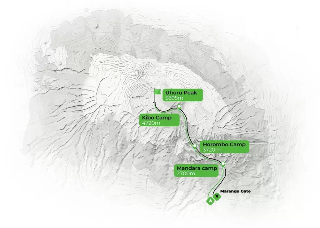
Machame Camp, Machame Camp, Shira Camp, to Lava Tower, Barranco Camp, Karanga Camp, Barafu Camp
Nicknamed the “Whiskey Route”, the Machame Route is known for being more challenging and slightly more expensive than the Marangu Route, but it rewards climbers with some of the most spectacular scenery on Mount Kilimanjaro. It is widely regarded as one of the best routes due to its excellent acclimatization profile and high success rate.
This route is ideal for adventurous trekkers or those with some hiking experience, as it involves steeper sections and longer trekking days. The trail approaches the summit from the southwest and descends via the Mweka route, offering diverse landscapes and dramatic views along the way.
The Machame Route is incredibly scenic and varied, passing through five distinct climatic zones—from dense rainforest to alpine desert and the arctic summit. Highlights include the Shira Plateau, Lava Tower, the Great Barranco Wall, and views beneath Kilimanjaro’s southern ice fields. Despite its popularity, it remains a top choice for those seeking a challenging trek with rewarding scenery and strong acclimatization through the “walk high, sleep low” principle.
Your journey begins with a short drive to Machame Gate, passing through local villages on the lower slopes of the mountain. After registration, the trek starts through a dense montane rainforest along a winding trail that gradually climbs up a ridge.
The path can be muddy and slippery, especially after rain, making the use of trekking poles helpful. The forest is rich in birdlife and monkeys, offering a lively and scenic introduction to the climb. You arrive at Machame Camp surrounded by thick forest.
Elevation: 1,830 m (6,000 ft) to 3,050 m (9,950 ft)
Distance: 11 km (7 miles)
Habitat: Montane Forest
After breakfast, you leave the rainforest behind and continue on a steep ascending trail across a rocky ridge. The landscape gradually opens up as you enter the moorland zone, with expansive views and fewer trees.
The route leads across valleys and ridges before reaching the Shira Plateau, one of the most scenic areas on the mountain. The air becomes cooler and thinner, marking your steady gain in altitude.
Elevation: 3,050 m (9,950 ft) to 3,850 m (12,600 ft)
Distance: 5 km (3 miles)
Habitat: Moorland
Today is an important acclimatization day. You trek across the Shira Plateau and continue toward Lava Tower, a prominent volcanic formation known as the “Shark’s Tooth.” This section involves gaining significant altitude before descending again, which helps your body adjust. After reaching the highest point of the day, you descend to Barranco Camp.
The scenery becomes more rugged, with dramatic views and unique vegetation. Despite ending the day at a similar elevation to where you started, this “walk high, sleep low” approach is key for summit success.
Elevation: 3,850 m (12,600 ft) to 4,650 m (15,250 ft) then down to 4,000 m (13,000 ft)
Distance: 10 km (6 miles)
Habitat: Semi-Desert
The day begins with the climb up the famous Barranco Wall, a steep but manageable scramble that rewards you with stunning views. After reaching the top, the trail continues across ridges and valleys toward Karanga Camp.
This is a shorter trekking day, allowing time for rest and further acclimatization. The landscape is dry and open, with striking views of the surrounding peaks.
Elevation: 4,000 m (13,000 ft) to 4,050 m (13,250 ft)
Distance: 5 km (3 miles)
Habitat: Alpine Desert
You continue your ascent toward Barafu Camp, completing the southern circuit of the mountain.
This route offers impressive views of the summit from different angles. The terrain is rocky and exposed, with very little vegetation. Upon arrival at camp, you will rest, have an early dinner, and prepare for the summit attempt. The excitement builds as you get closer to the final climb.
Elevation: 4,050 m (13,250 ft) to 4,700 m (15,350 ft)
Distance: 4 km (2 miles)
Habitat: Alpine Desert
Your summit attempt begins around midnight. You ascend steadily through loose volcanic scree toward Stella Point on the crater rim, the most physically and mentally demanding part of the climb. From there, you continue to Uhuru Peak, the highest point in Africa, where you are rewarded with breathtaking views and a memorable sunrise.
After celebrating your achievement, you begin the descent back to Barafu Camp for a short rest before continuing down to Mweka Camp. This is a long and demanding day, but incredibly rewarding.
Elevation: 4,700 m (15,350 ft) to 5,895 m (19,340 ft), then down to 3,090 m (10,150 ft)
Distance: 5 km (3 miles) ascent / 13 km (8 miles) descent
Habitat: Arctic Summit Zone to Montane Forest Edge
After breakfast, you continue your descent through the forest. The trail can be wet and muddy at lower elevations, but the air is warmer and the environment more lush. This final stretch is a relaxed walk as you make your way to Mweka Gate. Upon arrival, you receive your summit certificate, marking the successful completion of your Kilimanjaro adventure.
Elevation: 3,090 m (10,150 ft) to 1,680 m (5,500 ft)
Distance: 10 km (6 miles)
Habitat: Montane Forest
The best times are during the dry seasons:
A moderate to high level of fitness is recommended. Regular hiking and cardio training greatly improve your experience.
Health & Protection
6 Days The Marangu Route Kilimanjaro Climb
For More Details
6 Days The Rongai Route Kilimanjaro Climb
For More Details
7 Days The Machame Route Kilimanjaro Climb
For More Details